Boreal Landscapes - prince george south
|
|
Data PortalData type: Camera Data
Number of Cameras: 50 Area: 11,000 km2 Timespan: 2021-2023 Camera Data and Models: Email us to discuss data sharing Landcover Data: BC Data Catalogue. Metadata: See Publications, below. |
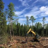
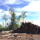
The Prince George South (PGS) study area is a sub-boreal region of the Interior Plateau of British Columbia. PGS supports a wide variety of human land use types, but the predominant form of resource extraction is logging. Following a mountain pine beetle (MPB) outbreak in the 1990s/2000s, the region was heavily salvage logged, leading to a landscape of massive cutblocks linked by extensive linear features.
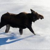
Prince George South is part of the Government of BC’s Moose Research Project which examines causes for moose population declines. The study area was selected due to its high level of MPB infestation and resource extraction.
Cameras deployed within the study area will be used in conjunction with the Government of BC’s radio-collared wolf and 8-month old calf moose data to understand the impacts of human landscape disturbance (primarily logging) on large carnivore distributions and moose habitat selection, survival and predation risk.
|
|